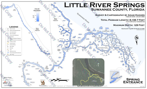
Little River Springs Cave System Map - Essential Navigation Tool for Cave Divers
The Little River Springs Cave System Map is an invaluable resource for divers exploring Florida cave springs diving. Surveyed and cartographed by Adam Hughes, this high-quality map provides comprehensive details of the underwater passages, helping divers plan and execute their dives with precision and safety.
Key Features and Benefits:
- Survey and Cartography: Created by renowned cave surveyor Adam Hughes, ensuring accuracy and reliability.
- High-Quality Material: Printed in full color on glossy styrene paper, providing excellent durability and water resistance.
- Large Dimensions: Measuring 28" x 46", the map offers a detailed and comprehensive view of the cave system.
- Detailed Cartography: Features precise details of Little River Springs, highlighting key areas, tunnels, and landmarks.
- Critical Navigation Aid: Essential for planning dives and navigating the complex underwater cave passages safely.
Detailed Description:
The Little River Springs Cave System Map is meticulously designed to assist divers in navigating the complex and expansive underwater passages of this renowned cave springs Florida. Known for its high-flow conditions and intricate network of tunnels, Little River Springs requires careful planning and precise navigation. This cave system map provides detailed cartography, highlighting key areas such as the main entrance, the natural limestone bridge, and various significant markers within the system.
Constructed from durable materials and laminated for protection, the map can withstand the rigors of cave diving use. Its large size (28 inches by 46 inches) ensures that divers can easily read and interpret the map while planning their dives. The detailed depiction of the cave’s layout helps divers avoid potential hazards and navigate the system efficiently.
Little River Springs is a popular destination for cave diving in Florida, attracting divers from around the world. The cave system features over 1,200 feet of mapped passages, offering a variety of exploration opportunities. The cave systems map includes critical information on the cave’s main pathways, side passages, and significant landmarks, providing a comprehensive guide for safe exploration.
Understanding the layout of Little River Springs is crucial, especially given the cave’s history of strong currents and complex tunnel systems. The map helps divers plan their gas management and navigate through the challenging conditions safely, ensuring a successful dive.
Specifications:
- Material: Printed on glossy styrene paper for durability and water resistance
- Dimensions: 28 inches x 46 inches
- Detail Level: High, with precise cartography of the cave system
Prepare for your next exploration of underwater caverns in Florida with the Little River Springs Cave System Map. This detailed and durable map, created by Adam Hughes, is essential for safe and effective navigation through one of the most intricate cave systems. Order now and dive with confidence, knowing you have the best navigational tool at your disposal!


